
Mapping the Global Seafloor Using Satellites and Ships: Recent Improvements from SWOT Gravity Using Machine Learning
Zoom link: https://osu.zoom.us/j/95270127089?pwd=Abso7mIZjNS8iLI4qjTp2WPxIKKDqe.1
Passcode: 810702
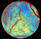
The ocean surface topography has broad bumps and dips caused by variations in gravity, which reflect the mass of seafloor features such as ridges, seamounts, and trenches. Because of this link, mapping sea surface topography allows us to infer seafloor depth, though physics limits the resolution to about 3–5 km in the deep ocean. Satellite altimeters have steadily improved these maps for decades, and the new SWOT mission now provides the most precise gravity data to date. In this study, five research groups used machine learning to combine SWOT gravity data with ship soundings, producing consistent global seafloor maps that are 23–46% more accurate than older methods. The
largest improvements are in mapping shallow seamounts and deep trenches, advancing our ability to study ocean circulation, tectonics, hazards, and marine ecosystems, while contributing to the international Seabed 2030 effort.